


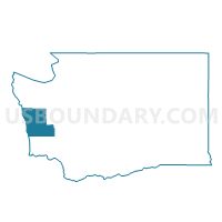
Wilderness Voting District, Grays Harbor County, Washington
About
Outline

Summary
| Unique Area Identifier | 684357 |
| Name | Wilderness Voting District |
| County | Grays Harbor County |
| State | Washington |
| Area (square miles) | 44.20 |
| Land Area (square miles) | 43.56 |
| Water Area (square miles) | 0.64 |
| % of Land Area | 98.56 |
| % of Water Area | 1.44 |
| Latitude of the Internal Point | 47.09837330 |
| Longtitude of the Internal Point | -124.00154250 |
Maps


Graphs
Select a template below for downloading or customizing gragh for Wilderness Voting District, Grays Harbor County, Washington


Neighbors
Neighoring Voting District (by Name) Neighboring Voting District on the Map
- Axford Voting District, Grays Harbor County, WA
- Hoquiam Rural Voting District, Grays Harbor County, WA
- Humptulips Voting District, Grays Harbor County, WA
- Moclips Voting District, Grays Harbor County, WA
- Ocean City Voting District, Grays Harbor County, WA
- Water: Grays Harbor Leg 24, Grays Harbor County, WA
Top 10 Neighboring County Subdivision (by Population) Neighboring County Subdivision on the Map
Top 10 Neighboring Unified School District (by Population) Neighboring Unified School District on the Map
- Hoquiam School District, WA (10,797)
- North Beach School District, WA (7,329)
- Lake Quinault School District, WA (1,187)